Close perusal of a topo map is a good way to launch this quest for the heart of the Cowees, in Jackson, Macon and Swain Counties, North Carolina. The Cowee Mountain range divides the watersheds of the Little Tennessee and Tuckasegee Rivers. Until the 1940s, those rivers converged at a point several miles west of Bryson City, North Carolina, but upon completion of the Fontana Dam, the point of their confluence is deep beneath the waters of the Fontana Lake.
If we call this the “lower” end of the Cowee Range, then it would take a crow’s flight of about 35 miles to the southeast to reach the “upper” end of the range: Highway 64 between Cashiers and Highlands, NC passes through Cowee Gap. Specifically, the gap is where the boundary between Jackson and Macon Counties intersects with the Eastern Continental Divide (ECD).
On one side of the ECD, waters flow to the Atlantic, and on the other, waters flow to the Mississippi River and, ultimately, the Gulf of Mexico. Facing south from Cowee Gap, you can view the impressive Whiteside Mountain and the headwaters of the Chattooga River, in the Savannah River watershed.
Looking south from Cowee Gap, Whiteside Mountain is at right
Look northward from the ECD, and you’ll see upper reaches of the Tennessee Valley watershed. The headwaters of the Little Tennessee are to the west of the Cowee ridge, and the headwaters of the Tuckasegee are to the east.
The crest of the Cowee range is easy to follow on a map. Why? When Jackson County was carved out of Macon County in 1851, the new boundary followed the divide between the Little Tennessee and the Tuckasegee. I enjoy tracing this county border on a good topo map and reading the names along the dotted line that runs from peak to peak.
If only, I tell myself, if only a hiking trail followed this line. What a great adventure it would be to hike the full extent of the Cowee Crest, from Cowee Gap to Fontana Lake! The Nantahala National Forest includes vast swaths of the Cowees, but intervening tracts of private land would render the construction of a continuous ridegetop trail all but impossible. Still, it is fun to imagine how such a trail would have changed perceptions of the Cowee Mountains, and an “identity” for the range as a whole might have entered the public consciousness.
Lookout tower at Yellow Mountain, highest point in the Cowees
Fortunately, one well-maintained trail does wind along several miles of the Cowee ridge, leading to the highest point on the range at Yellow Mountain (5127’ elevation). This is arguably the best hike in the Cowee Mountains and is in the top tier of the most outstanding hikes in the entire Southern Appalachians.
There’s no better place than the historic fire lookout tower atop Yellow Mountain to contemplate the question, “Just what makes the Cowee Mountains the Cowee Mountains?” In subsequent installments, I’ll be proposing some possible answers to that question.
[What better way to commence this site than with an article about Silas McDowell. I’ve been inspired by his work for more than forty years and wrote this piece for theSpring 1992 edition of Katuah Journal. McDowell lived near the Cullasaja River in Macon County in the 19th century and in innumerable letters and articles shared his own explorations of the Cowees. This will be the first of many posts featuring Silas McDowell.]
Amongst the valleys of the southern Alleghanies sometimes winter is succeeded by warm weather, which, continuing through the months of March and April, brings out vegetation rapidly, and clothes the forests in an early verdure. This pleasant spring weather is terminated by a few days’ rain, and the clearing up is followed by cold, raking winds from the northwest, leaving the atmosphere of a pure indigo tint, through which wink bright stars, but if the wind subsides at night, the succeeding morning shows a heavy hoar frost; vegetation is utterly killed, including all manner of fruit germs, and the landscape clothed in verdure the day before now looks dark and dreary. – Silas McDowell
On the morning of April 28, 1858, Silas McDowell encountered this bleak scene when he went out to inspect his farm. The Macon County fruit grower had spent almost thirty years establishing his orchard of 600 apple trees near the banks of the Cullasaja River. However, this late spring freeze “made nearly a clean sweep from our mountain valleys in Western North Carolina of the richest promise of a fruit crop that we have ever had.” For anyone else, the incident would have been a crushing disappointment. For McDowell, it was another opportunity to examine nature’s mysteries and to find a better way of farming in the mountains.
McDowell had deliberately selected a sheltered valley for his orchard. Only a settler too poor to buy bottom land would have tried to grow fruit high on the mountainsides. And yet, on this April morning, McDowell realized his mistake. While his own trees “seemed as if clothed in a black pall,” he observed on the mountains looming over his orchard a broad horizontal band of vegetation left unscathed by the freeze.
Around 1780, Thomas Jefferson had witnessed similar temperature inversions in the Shenandoah Mountains of Virginia. He reported, “I have known frosts so severe as to kill the hiccory trees round about Monticello, and yet not injure the tender fruit blossoms then in bloom on the top and higher parts of the mountain.” Silas McDowell understood that this was more than simply a quirk of topography and climate. He suspected that thermal belts could be the secret to successful fruit production in mountainous areas.
By the summer of 1858 he wrote that “all description of fruit trees which have the good fortune to be located in this vernal region, are now bending beneath a heavy crop of fruit.” He began to promote the value of this zone for fruit growers and contributed a report to the United States Agricultural Reports for 1861. In his article on the “belt of no frost” McDowell explained:
The beautiful phenomenon of the ‘Verdant Zone’ or ‘Thermal Belt’ exhibits itself upon our mountain sides, commencing about three hundred feet vertical height above the valleys, and traversing them in a perfectly horizontal line throughout their entire length like a vast green ribbon upon a black ground.
Born in South Carolina in 1795, McDowell moved to Asheville in his youth for training as a tailor. He practiced his trade in Charleston and Morganton before settling in Macon County’s Cullasaja Valley, where he gained renown as a fruit grower, amateur naturalist and story teller. His articles on the mountains were published in popular magazines and caught the attention of leading botanists, who sought his help in finding rare plants of the Southern Appalachians. When a visiting scientist asked which college he had attended, McDowell pointed to the hills surrounding his farm and replied, “These wild mountains are the only college at which my name has ever been entered as a student!” In a tribute to Silas McDowell, T. F. Glenn remembered him as modest and unassuming, and also:
…intuitive, impulsive and passionate. His companionship with nature was a marked feature of his character. His glowing imagination imparted to the most trivial objects beauty and sublimity. By a native force of genius, by dint of fiery energy of will, by persistent application, he surmounted obstacles.
McDowell’s tenacious efforts to raise winter keeping apples had earned him a reputation among southern fruit growers even before the thermal belt episode. When McDowell and his bride, Elizabeth, moved to Macon County in 1830 they brought a baby’s cradle filled with small apple trees from her grandfather’s orchard near Asheville. Being especially fond of winter apples, McDowell chose varieties recommended by northern pomologists. His results were like those of other southern growers:
I made a complete failure, for when my trees began to bear fruit, it matured and fell from the tree long before the proper time, and though they were an excellent collection of Autumn Apples, there was not a good Winter keeper amongst them.
For fifteen years, McDowell struggled to raise winter keepers. Then, the editor of a farm paper in Athens, Georgia suggested that he take grafts from native seedling apples. McDowell followed James Carmack’s advice and searched the hills around his home for fruit stock. He found what he had been looking for:
Amongst old Cherokee seedling Apple trees – as well as other Southern seedlings, I have succeeded in conferring on Southern Pomology a list of names of Winter Apples, which both as to their highly aromatic taste, as well as late winter keeping qualities, cannot be excelled by as many varieties of Winter Apples in the United States.
His catalog of new apples featured the Carmack, Nickajack, Bullasage, Mavereck Winter Sweet, Royal Pearmam, Hoover, Golden Pippin, Buff, Kingrussett and Neverfail. “None but late keepers in the list,” McDowell noted with delight. In 1870, William Saunders with the Agriculture Department concluded, “There is not a doubt about it, the finest winter apples in America are grown on these mountain lands.” McDowell could take much of the credit.
McDowell, always concerned with the region’s economy, believed that vineyards established within the thermal belt could be a mainstay of mountain agriculture. “The Grape,” McDowell predicted:
…will never fail to yield to the husbandman a rich and abundant crop of its luscious and heart-cheering fruit; and had the vine locomotion, corporal and mental sense, I would bid it to ‘Tarry not in all the plains; but flee to the mountains for its life,’ and take refuge under the protection of the Thermal Stratum!
Much as he had in his quest for winter apples, McDowell explored the mountains to find superior varieties of grapes. He speculated on the potential of hybridizing some of the specimens:
We cannot well command our risibles when, in fancy, we anticipate the aspect of that monster Grape that will be produced by the hybridal cross betwixt the Hon. A. G. Semmes’s eight pound bunches and the Mammoth Grape Prof. C. D. Smith and ourself measured yesterday, the single berries of which girted three and a quarter inches round.
After the Civil War, McDowell continued to write on agricultural topics, presided over the Fruit Growers Association and pleaded for extension of the Western North Carolina Railroad. He was constantly learning more – from natural phenomena, the culture of the Cherokees and the latest farm journals. In his judgment, the climate and terrain of the mountains did not have to be obstacles to successful farming. Instead, the unique character of the mountains could support a distinctive form of agriculture.
Diversity was one aspect of the mountain agriculture he envisioned:
Dairying, grape culture, bee culture, sheep husbandry supplemented by a woolen cloth factory. Are these the only items of new industries our mountain section is capable of?
He went on to suggest one more:
I have recently learned that a man studied Fish culture, constructed him a three-acre pond near the city of Atlanta, Ga., and then from Florida procured a can of eggs of the Scaly Trout species.
After hatching the eggs and raising the fish to maturity, the man realized an income of fifteen thousand dollars in one year. Wanting to attempt a similar venture with mountain trout, McDowell had a small pond built amid a grove of oaks near his home:
Their feed will consist of the waste from the kitchen and table, with all small animals that come my way, chopped up fine, supplemented by a lazy cat, in an emergency. There is nothing but the lack of a pure stream and vim to hinder any man having a mountain farm, to do the same thing, and have a fat trout for breakfast every day the year through.
McDowell lived long enough to see the impact of extractive industries on the mountain environment. When Western North Carolina’s first corundum mine opened near McDowell’s farm in 1871, he turned a disaster into a blessing. Thirty years before, a flood had swept across the best portion of his farm, “a fertile bottom-field of about 50 acres.” McDowell described the damage. “I found that field, on which I expected to make forty bushels of corn to the acre, to be a miniature Sahara of white sand, and would no longer pay the expense of resetting and keeping up the fences.”
The field had remained in this condition until the coming of the corundum mine, which was polluting the Cullasaja River. “As the mine was worked by means of a hose-pipe, a red stream of clay and water came running down the mountain’s side defiling our beautiful river and chasing away the fish.” It occurred to McDowell that he could protect the river and reclaim his field at the same time:
Thanks to Sir Samuel Baker for his suggestions in relation to redeeming some of the African deserts by sitting them with the muddy waters of the Nile. And I forthwith applied to Col. Jenks, who controlled the mine, for leave to run a ditch down the mountain from the mine to my sands – a distance of three-fourths of a mile. The next thing I did, was to throw up a dike on the river side of the bottom, to hold on the sands the muddy waters until they are absorbed – a thing not hard to do, as the sands swallow them up very fast and ‘thirst for more.’ The water of my ditch performs the carrying service of ten dump carts, and does the thing for nothing and we may add, loads itself. This enterprise I view as my last act in life’s drama, and I feel ambitious to do the thing well, and make my best bow to my fellow-farmers as the curtain drops.
Silas McDowell died in 1879. His life work, promoting agricultural practices appropriate to the region, endures. McDowell brought curiosity, ingenuity, perseverance and humor to the task, qualities that would enhance any efforts to renew mountain agriculture as we approach the 21st century.
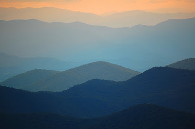
Sunset on the Cowees, viewed from Richland Balsam, 2009
Having hiked and explored most of the mountain ranges in Western North Carolina, I can attest to the fact that different ranges have different personalities. Whether picking blueberries in the Great Balsams, climbing the lofty Crest Trail in the Black Mountains, or enjoying the long-range views from the grassy balds of the Roans, I’m aware that each location has distinct characteristics. Often, a photo can distill the essence of a range, especially the three ranges that I’ve just mentioned.
Sometimes, it is easy to find the words to describe a mountain range and how it is unlike the next. More often, though, the less charismatic ranges conceal their personalities. After inhabiting a patch of land in the Cowee Mountains for several decades, I still strive to understand and communicate just what makes them the Cowees, besides their geographic position dividing the waters of the Little Tennessee from the Tuckasegee.
After all these years, I still don’t have many answers, but I do feel the need to continue asking, “What is the heart of the Cowees?” So, that ongoing effort will be one aspect of this website.
But that’s not all. I have journals and notes from many travels throughout the Southern Appalachians and beyond. This will be a site to compile those accounts and to indulge my other research interests, such as the ethnogenesis of native people in the region, place names, agriculture, panther sightings past and present, wildflower photography, vanished places, vintage postcards, old maps, utopian schemes and much more.
My research has led me to many obscure documents from the past five hundred years that shed light on the southern mountains and the Southeast in general. I intend to feature extended passages from some of those accounts. Tourism promoters and history professors have their own way of spinning the story of these mountains, and I hope to counterbalance some of their unfortunate excesses, one story at a time. Perhaps, in a small way, I can share the joy I have experienced in my explorations of the land and the historical record.